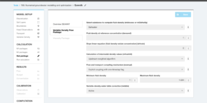
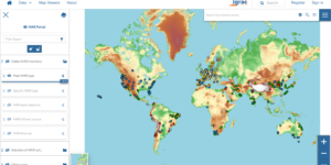
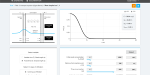
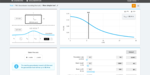
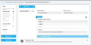
T15: Quantitative microbial risk assessment
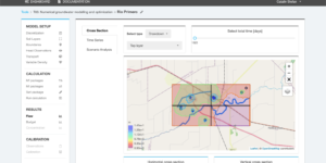
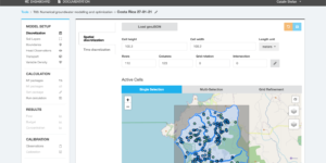
The tool helps to quantify the pathogen occurrence in source water and their removal by various treatment steps at MAR facilities by using a probabilistic approach. The interactive web-based QMRA …
The real-time modelling tool allows a user to extend an existing numerical groundwater flow model with new sensor data. New stress periods are automatically added to the basis model using …
Subsurface travel time from the area of recharge to the point of abstraction during MAR is a critical parameter to ensure sufficient attenuation for hygienic parameters and other undesired substances. …
This tool encompasses a web-based monitoring system developed to integrate time series data into the INOWAS platform. Real-time sensors can be connected to the INOWAS platform and time series data …
Variable-density flow can be added to the numerical groundwater flow and transport simulation using SEAWAT. The implementation is based on FloPy (Bakker et al, 2016). A requirement is that a …
This tool combines GIS-based geospatial analysis with multi-criteria decision analysis for the web-based compilation of MAR suitability maps.
The tool is a database that processes information about experimental test results monitoring the infiltration capacity decrease in spreading infiltration basins due to clogging and climate related issues.
The tool helps in the selection of a suitable model for the evaluation of MAR specific issues.
The tool makes us of empirical equations to design a typical SAT-system including hydraulic loading rates and land requirements under consideration of soil hydraulic characteristics and water quality.
GIS-based global inventory of managed aquifer recharge schemes with over 1,200 case studies collected from more than 50 countries worldwide.
Pumping from wells besides streams lowers the groundwater level and reduces surface water flow within the stream. This tool helps to estimate the stream depletion rate induced by well pumping.
This tool estimates the travel time in an unconfined aquifer under various boundary conditions. Four different options of boundary conditions that bound the aquifer are included.
The tool contains analytical equations that can be used to analyse or predict the location of the interface between sea water and fresh water in a groundwater system. Start using …
This tool solves the 1D advection-dispersion equation using the Ogata-Banks solution as function of transport properties, source concentration, time of interest and distance from the source.
This tool makes use of the output files of the MODFLOW-based model and uses them for the customised analysis of user-defined model scenarios
The data-driven tool provides support in the selection of suitable MAR methods based on the analysis of several hundreds of MAR case studies worldwide
Query tool for the visualisation and assessment of different components of GIS-based multi-criteria decision analysis used in the selection of suitable sites for MAR implementation.
The simulation of solute transport can be integrated in the groundwater flow simulation (see T03.Numerical groundwater modelling and optimization) using MT3DMS or MT3DMS-USGS. The implementation is based on FloPy (Bakker …
The tool helps to setup a new MODFLOW model for a study area e.g. to better understand the local groundwater flow system or as a basis for scenario analysis.
The Groundwater Mounding Calculator is solving the Hantush analytical equation (Hantush, 1967) for groundwater mounding beneath an infiltration basin.