Query tool for the visualisation and assessment of different components of GIS-based multi-criteria decision analysis used in the selection of suitable sites for MAR implementation.
To assess the tendencies and preferences applied by the scientific community for MAR site selection using GIS based Multi-Criteria Decision Analysis (GIS-MCDA) a review of available literature was conducted. It resulted in a database with 66 scientific documents from more 18 countries. Based on the database a query tool was developed. This tool will help to use the database in a structured way by querying in order to summarize, analyze and explore the obtained results.
The original database can be downloaded here. A simplified version was uploaded for the query tool.
The GIS-MCDA MAR site selection database
The database was constructed to store and retrieve information related to the methodology used by different authors that applied GIS-MCDA for MAR site selection. Some of the most relevant questions that were formulated and that can be answered by using the database are the following:
- Which MAR type is GIS-MCDA mostly applied for?
- Which water sources were regarded for the studies?
- Which criteria are used the most for GIS-MCDA MAR sites selection? Are there differences regarding the MAR type?
- How often is constraint mapping used for GIS-MCDA MAR site selection? Which thresholds are applied?
- Which weighting assignment methods are used?
- Which decision rules are used the most?
- How often is sensitivity analysis included in GIS-MCDA MAR site selection?
The database was constructed based on the retrieved criteria. This means that each reviewed document has the same number of entries as the number of criteria selected by each author. The following table present all attributes of the database and their meaning (see Table 1):
Table 1. List of database attributes for query tool
| ATTRIBUTE NAME | DESCRIPTION |
| ID | Unique identification number for each reviewed document. |
| Document reference | First author of the document and the year of publication. |
| Publication year | Year that the document was published. |
| Study case location | Country where the study was conducted. |
| Spreading methods | Yes or No, indicating if this MAR type method was used or not. |
| Induced bank filtration | Yes or No, indicating if this MAR type method was used or not. |
| In-channel modifications | Yes or No, indicating if this MAR type method was used or not. |
| Well, shaft, borehole recharge | Yes or No, indicating if this MAR type method was used or not. |
| Rainwater harvesting | Yes or No, indicating if this MAR type method was used or not. |
| Unspecified | Yes or No, indicating if the author did not specifiy the MAR type. |
| Number of criteria used | Number of criteria used in study |
| Criteria original | Criterion as stated by the author to determine MAR site suitability. |
| Criteria modified | Harmonized criterion selected by the author to determine MAR site suitability. |
| Criteria category (main) | Main criteria categories: aquifer, hydrometeorology, management, surface and water quality |
| Criteria category (specific) | Subcategories to the five main categories |
| Criteria weight | Weight assigned to criteria. |
| Criteria importance rank | Ranking to establish an order of weight or importance for each criterion. The most important criterion is assigned the rank 1. |
| Weight assignment method | Weighting assignment method used |
| Decision rules | Combination rules used for combining weights and criteria sets |
| Constraint mapping | If value is Yes, the author used constraint mapping. |
| Constraint mapping | List of constraints and thresholds |
| Sensitivity analysis | If value is Yes, the author did a sensitivity analysis. |
| Water source | Water source used for groundwater recharge. |
| Main objective of MAR | Objective of MAR application |
The database query tool
In order to query the information contained in the database, a pivot table application was created. Pivot tables are useful tools to query information in a flexible and intuitive way. Users can drag, drop, and filter attributes content to create tables and obtain statistical results. Documents can be filtered to search for literature that should be further.
The pivot table implemented was developed by Nicolas Kruchten in an open-source third-party project named react-pivottable under MIT-License (https://github.com/nicolaskruchten/pivottable).
The tool interface
The INOWAS query tool works by dragging and dropping attributes from the database into the column or row fields. The user can filter the content of each attribute, can specify how the information should be displayed and add conditional or numerical operator to the pivot table. The following image presents the main objects of the query tool interface (Figure 1):
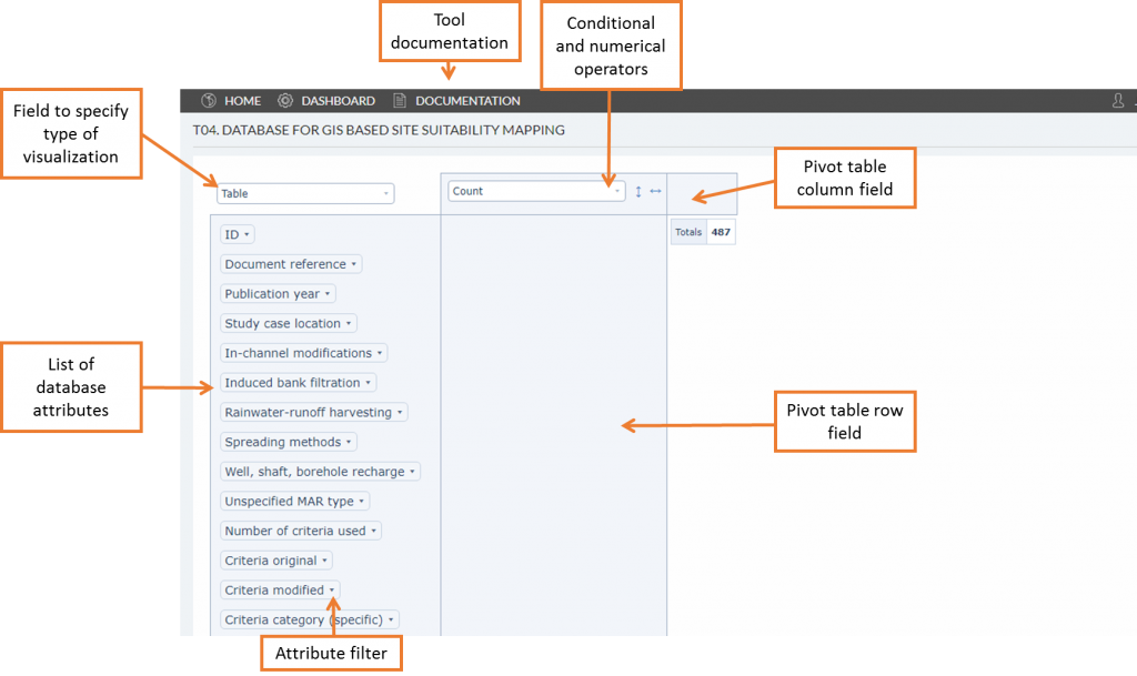
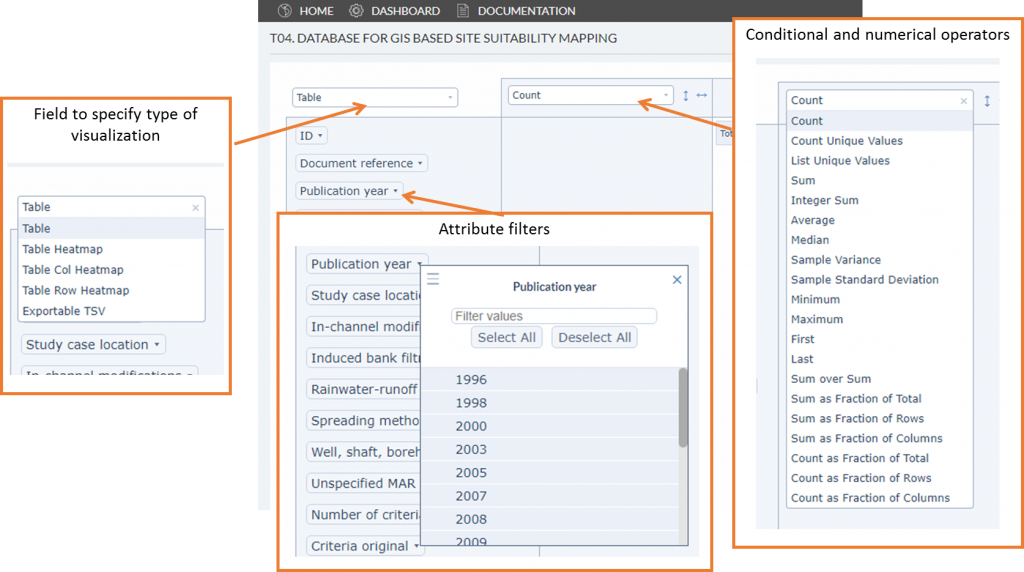
The user can specify how information should be displayed by the pivot table with the options Table, Table Heatmap, Table Col Heatmap, Table Row Heatmap, and Exportable TSV (Figure 2). The last option is useful to export filtered information.
Conditional and mathematical operator can be included to obtain specific results. Count, Count Unique Values and List Unique Values are the most commonly used operators for lingustic attributes (see Figure 2). Further operators that are specifically useful when working with numeral values are Sum, Average, Median, Minimum, Maximum and Sample Variance.
Filters can be applied to attribute content. By clicking on the attributes, a list of the information that it contains will be displayed. The user can select which information should be displayed and counted in the pivot tables. When filters are active, the attribute name will appear in italic characters.
Query examples
The INOWAS query tool can be used in different ways because of its operational flexibility. Some examples will be provided based on the main questions that launched this project. These examples are prepared to get the user started on the usability of the tool but it should be kept in mind that there are many other options to visualize the same results or to query information.
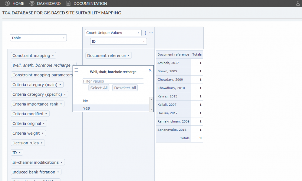
EXAMPLE 1. How many and which documents are used for well, shaft and borehole (WSB) recharge analysis?
Querying the documents that are based on a specific MAR type and counting them can be achieved by following these steps:
- Filter the attribute
Well, shaft and borehole rechargetoYes. - Drag and drop
Document referenceattributes to the row field. - Select the operator called
Count Unique Values. The database was constructed based on the number of criteria for each document. So, in this example the reference “Amineh, 2017” would be counted nine times, as nine criteria were used. Usingcount unique valueswill count only one value per document and not the number of criteria used for each document. Under the operator field it needs to be specified which attribute should be regarded for counting. In this caseIDneeds to be selected.
The results indicate that nine documents were used with well, shaft and borehole recharge as MAR type. The pivot table also displays the reference to search for it (Figure 3).
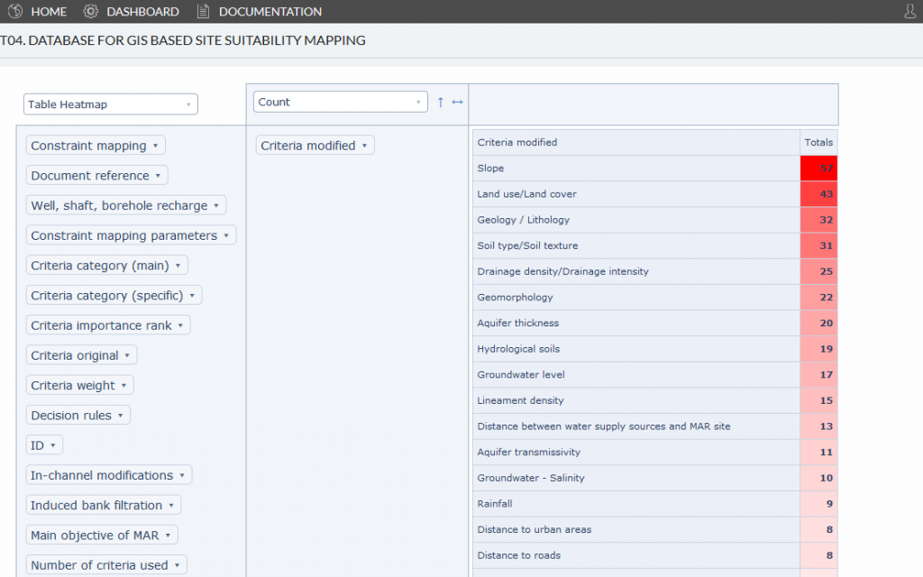
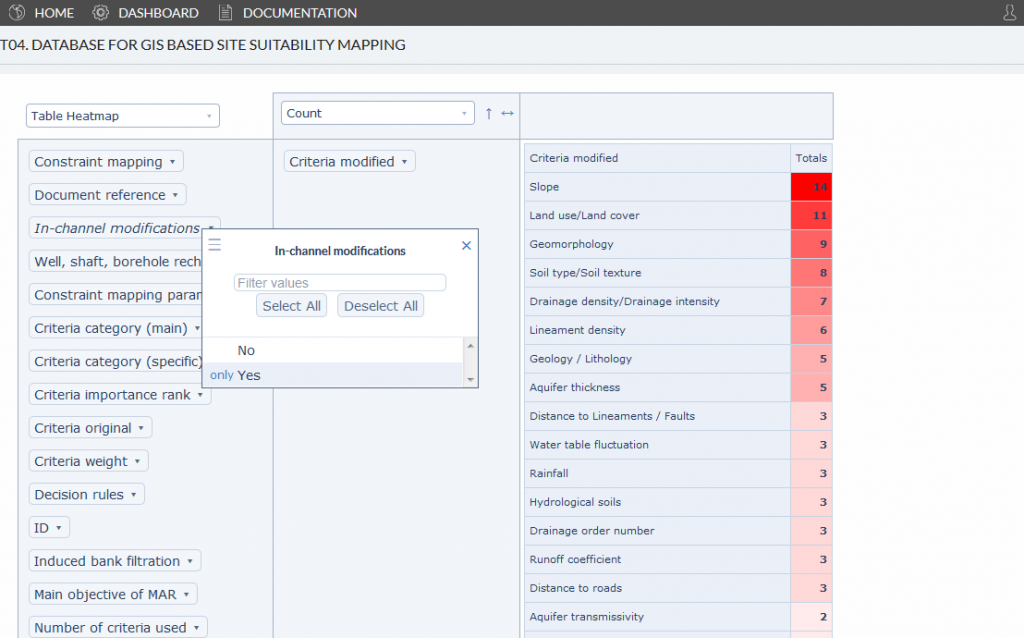
EXAMPLE 2. Which are the most used criteria for GIS-MCDA MAR site selection? Which are the most used criteria for GIS-MCDA In-channel modification site selection?
If the user what to know which are the most used criteria for GIS-MCDA MAR site selection and which are the most used for In-channel modifications, the following steps could be applied:
- Drag and drop the
Criteria modifiedattribute to the row field. - Display the pivot table as
Table Heatmap. - Use the
Countmathematical operator. - Click on the arrow next to the Operator field to organize counted values from highest to lowest value.
The results allow the user to see that slope was the criterion used the most, selected in 57 documents for MAR site selection. Land use/ land cover was used the second most often, followed by geology/lithology (Figure 4).
To find out which are the most used criteria for in-channel modifications site selection, the database needs to be filtered by documents that use in-channel modifications for their analysis. Select as a filter only the In-channel modifications with the Boolean value Yes. The results show that slope was the most used criterion, followed by land use/land cover and geomorphology (Figure 5).
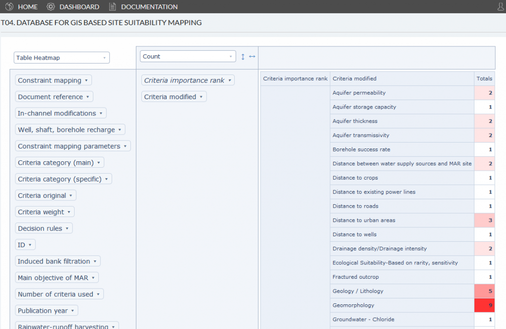
EXAMPLE 3. Which criteria are ranked the highest for GIS-MCDA MAR site selection?
For this example, we want to know which criteria are preferred as the most important for GIS-MCDA MAR site selection. The concept of importance is based on the criteria with the highest rank assigned. For building this query, the following steps can be followed:
- Drag and drop the
Criteria importance rankattribute to the row field. - Filter the
Criteria importance rankattribute by only showing1and2(most important criteria). - Display the pivot table as
Table Heatmap. - Use the Count mathematical operator and sort from highest to lowest value.
- Drag and drop the
Criteria modifiedattribute to the row field underneath theCriteria importance rankattribute.
Using this procedure, the user can observe which criteria were assigned the highest importance rank the most. Results show that slope was the highest ranked criterion, followed geomorphology, land use/land cover and hydrological properties of soils (see Figure 6). Filtering Criteria importance rank to another number will show the listing for the respective criterion rank.
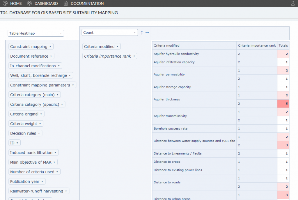
The visualized results are first ordered by the criterion rank. A better way to display the results would be to change the order of attributes in the pivot table row field. Shifting Criteria modified above Criteria importance rank will sort the results first by criteria category (Figure 7). This visualization makes it easier to look for a specific criterion and see if and how often it was used as highest ranked (Rank 1 or 2).
References of analyzed studies
-
- Agarwal, R., Garg, P.K., Garg, R.D., 2013. Remote Sensing and GIS Based Approach for Identification of Artificial Recharge Sites. Water Resources Management 27, 2671–2689. https://doi.org/10.1007/s11269-013-0310-7
-
- Ahmadi, M.M., Mahdavirad, H., Bakhtiari, B., 2017. Multi-criteria analysis of site selection for groundwater recharge with treated municipal wastewater. Water Science and Technology 76, 909–919. https://doi.org/10.2166/wst.2017.273
-
- Al-Adamat, R., 2012. The Use of GIS and Google Earth for Preliminary Site Selection of Groundwater Recharge in the Azraq Oasis Area—Jordan. Journal of Water Resource and Protection 04, 395–399. https://doi.org/10.4236/jwarp.2012.46045
-
- Alesheikh, A.A., Soltani, M.J., Nouri, N., Khalilzadeh, M., 2008. Land assessment for flood spreading site selection using geospatial information system. Int. J. Environ. Sci. Technol. 5, 455–462. https://doi.org/10.1007/BF03326041
-
- Alraggad, M., Jasem, H., 2010. Managed Aquifer Recharge (MAR) through Surface Infiltration in the Azraq Basin / Jordan. Journal of Water Resource and Protection 02, 1057–1070. https://doi.org/10.4236/jwarp.2010.212125
-
- Amineh, Z.B.A., Hashemian, S.J.A.-D., Magholi, A., 2017. Integrating Spatial Multi Criteria Decision Making (SMCDM) with Geographic Information Systems (GIS) for delineation of the most suitable areas for aquifer storage and recovery (ASR). Journal of Hydrology, Investigation of Coastal Aquifers 551, 577–595. https://doi.org/10.1016/j.jhydrol.2017.05.031
-
- Anane, M., Kallali, H., Jellali, S., Ouessar, M., 2008. Ranking suitable sites for Soil Aquifer Treatment in Jerba Island (Tunisia) using remote sensing, GIS and AHP-multicriteria decision analysis. International Journal of Water 4, 121. https://doi.org/10.1504/IJW.2008.018151
-
- Bonilla Valverde, J.P., Blank, C., Roidt, M., Schneider, L., Stefan, C., 2016. Application of a GIS Multi-Criteria Decision Analysis for the Identification of Intrinsic Suitable Sites in Costa Rica for the Application of Managed Aquifer Recharge (MAR) through Spreading Methods. Water 8, 391. https://doi.org/10.3390/w8090391
-
- Brown, C.J., Weiss, R., Verrastro, R., Schubert, S., 2005. Development of an Aquifer, Storage and Recovery (ASR) Site Selection Suitability Index in Support of the Comprehensive Everglades Restoration Project. Journal of Environmental Hydrology 13, 1–13.
-
- Chenini, I., Mammou, A.B., May, M.E., 2010. Groundwater Recharge Zone Mapping Using GIS-Based Multi-criteria Analysis: A Case Study in Central Tunisia (Maknassy Basin). Water Resour Manage 24, 921–939. https://doi.org/10.1007/s11269-009-9479-1
-
- Chezgi, J., Pourghasemi, H.R., Naghibi, S.A., Moradi, H.R., Zarkesh, M.K., 2015. Assessment of a spatial multi-criteria evaluation to site selection underground dams in the Alborz Province, Iran. Geocarto International 31, 628–646. https://doi.org/10.1080/10106049.2015.1073366
-
- Chowdary, V.M., Ramakrishnan, D., Srivastava, Y.K., Chandran, V., Jeyaram, A., 2009. Integrated Water Resource Development Plan for Sustainable Management of Mayurakshi Watershed, India using Remote Sensing and GIS. Water Resources Management 23, 1581–1602. https://doi.org/10.1007/s11269-008-9342-9
-
- Chowdhury, A., Jha, M.K., Chowdary, V.M., 2010. Delineation of groundwater recharge zones and identification of artificial recharge sites in West Medinipur district, West Bengal, using RS, GIS and MCDM techniques. Environ Earth Sci 59, 1209. https://doi.org/10.1007/s12665-009-0110-9
-
- Daher, W., Pistre, S., Kneppers, A., Bakalowicz, M., Najem, W., 2011. Karst and artificial recharge: Theoretical and practical problems. Journal of Hydrology 408, 189–202. https://doi.org/10.1016/j.jhydrol.2011.07.017
-
- Dashtpagerdi, M.M., Nohegar, A., Vagharfard, H., Honarbakhsh, A., Mahmoodinejad, V., Noroozi, A., Ghonchehpoor, D., 2013. Application of Spatial Analysis Techniques to Select the Most Suitable Areas for Flood Spreading. Water Resour Manage 27, 3071–3084. https://doi.org/10.1007/s11269-013-0333-0
-
- Dorfeshan, F., Heidarnejad, M., Bordbar, A., Daneshian, H., 2014. Locating Suitable Sites for Construction of Underground Dams through Analytic Hierarchy Process. Presented at the International Conference on Earth, Environment and Life sciences, International Institute of Chemical, Biological & Environmental Engineering, Dubai. https://doi.org/10.15242/IICBE.C1214072
-
- Fernández Escalante, E., Calero Gil, R., San Miguel Fraile, M.Á., Sánchez Serrano, F., 2014. Economic Assessment of Opportunities for Managed Aquifer Recharge Techniques in Spain Using an Advanced Geographic Information System (GIS). Water 6, 2021–2040. https://doi.org/10.3390/w6072021
-
- Gdoura, K., Anane, M., Jellali, S., 2015. Geospatial and AHP-multicriteria analyses to locate and rank suitable sites for groundwater recharge with reclaimed water. Resources, Conservation and Recycling 104, 19–30. https://doi.org/10.1016/j.resconrec.2015.09.003
-
- Ghayoumian, J., Ghermezcheshme, B., Feiznia, S., Noroozi, A.A., 2005. Integrating GIS and DSS for identification of suitable areas for artificial recharge, case study Meimeh Basin, Isfahan, Iran. Environmental Geology 47, 493–500. https://doi.org/10.1007/s00254-004-1169-y
-
- Ghayoumian, J., Mohseni Saravi, M., Feiznia, S., Nouri, B., Malekian, A., 2007. Application of GIS techniques to determine areas most suitable for artificial groundwater recharge in a coastal aquifer in southern Iran. Journal of Asian Earth Sciences 30, 364–374. https://doi.org/10.1016/j.jseaes.2006.11.002
-
- Goodarzi, L., Akhoond-Ali, A., Zarei, H., Dehghani, F., 2013. Identifying potential sites for artificial groundwater recharge using GIS and MCDM techniques in Oshtorinan plain, Iran. Ecology, Environment and Conservation Paper 19, 685–690.
-
- Jamali, I.A., Mörtberg, U., Olofsson, B., Shafique, M., 2014. A Spatial Multi-Criteria Analysis Approach for Locating Suitable Sites for Construction of Subsurface Dams in Northern Pakistan. Water Resources Management 28, 5157–5174. https://doi.org/10.1007/s11269-014-0800-2
-
- Jasrotia, A.S., Kumar, R., Saraf, A.K., 2007. Delineation of groundwater recharge sites using integrated remote sensing and GIS in Jammu district, India. International Journal of Remote Sensing 28, 5019–5036. https://doi.org/10.1080/01431160701264276
-
- Jothiprakash, V., Marimuthu, G., Muralidharan, R., Senthilkumar, N., 2003. Delineation of potential zones for artificial recharge using gis. J Indian Soc Remote Sens 31, 37–47. https://doi.org/10.1007/BF03030750
-
- Kaliraj, S., Chandrasekar, N., Magesh, N.S., 2015. Evaluation of multiple environmental factors for site-specific groundwater recharge structures in the Vaigai River upper basin, Tamil Nadu, India, using GIS-based weighted overlay analysis. Environ Earth Sci 74, 4355–4380. https://doi.org/10.1007/s12665-015-4384-9
-
- Kallali, H., Anane, M., Jellali, S., Tarhouni, J., 2007. GIS-based multi-criteria analysis for potential wastewater aquifer recharge sites. Desalination 215, 111–119. https://doi.org/10.1016/j.desal.2006.11.016
-
- Krishnamurthy, J., Kumar, N.V., Jayaraman, V., Manivel, M., 1996. An approach to demarcate ground water potential zones through remote sensing and a geographical information system. International Journal of Remote Sensing 17, 1867–1884. https://doi.org/10.1080/01431169608948744
-
- Krishnamurthy, J., Mani, A., Jayaraman, V., Manivel, M., 2000. Groundwater resources development in hard rock terrain – an approach using remote sensing and GIS techniques. International Journal of Applied Earth Observation and Geoinformation 2, 204–215. https://doi.org/10.1016/S0303-2434(00)85015-1
-
- Magesh, N.S., Chandrasekar, N., Soundranayagam, J.P., 2012. Delineation of groundwater potential zones in Theni district, Tamil Nadu, using remote sensing, GIS and MIF techniques. Geoscience Frontiers 3, 189–196. https://doi.org/10.1016/j.gsf.2011.10.007
-
- Mahdavi, A., Tabatabaei, S.H., Mahdavi, R., Emamzadei, M.R.N., 2013. Application of digital techniques to identify aquifer artificial recharge sites in GIS environment. International Journal of Digital Earth 6, 589–609. https://doi.org/10.1080/17538947.2011.638937
-
- Mahmoud, S.H., Alazba, A.A., Adamowski, J., El-Gindy, A.M., 2015. GIS methods for sustainable stormwater harvesting and storage using remote sensing for land cover data – location assessment. Environmental Monitoring and Assessment 187. https://doi.org/10.1007/s10661-015-4822-x
-
- Mahmoud, S.H., Alazba, A.A., T, A.M., 2014. Identification of Potential Sites for Groundwater Recharge Using a GIS-Based Decision Support System in Jazan Region-Saudi Arabia. Water Resour Manage 28, 3319–3340. https://doi.org/10.1007/s11269-014-0681-4
-
- Mahmoud, S.H., Tang, X., 2015. Monitoring prospective sites for rainwater harvesting and stormwater management in the United Kingdom using a GIS-based decision support system. Environmental Earth Sciences 73, 8621–8638. https://doi.org/10.1007/s12665-015-4026-2
-
- Malekmohammadi, B., Ramezani Mehrian, M., Jafari, H.R., 2012. Site selection for managed aquifer recharge using fuzzy rules: integrating geographical information system (GIS) tools and multi-criteria decision making. Hydrogeology Journal 20, 1393–1405. https://doi.org/10.1007/s10040-012-0869-8
-
- Mehrabi, H., Zeinivand, H., Hadidi, M., 2013. Site Selection for Groundwater Artificial Recharge in Silakhor Rangelands Using GIS Technique. Journal of Rangeland Science 2, 687–695.
-
- Nasiri, H., Boloorani, A.D., Sabokbar, H.A.F., Jafari, H.R., Hamzeh, M., Rafii, Y., 2013. Determining the most suitable areas for artificial groundwater recharge via an integrated PROMETHEE II-AHP method in GIS environment (case study: Garabaygan Basin, Iran). Environmental Monitoring and Assessment 185, 707–718. https://doi.org/10.1007/s10661-012-2586-0
-
- Owusu, S., Mul, M.L., Ghansah, B., Osei-Owusu, P.K., Awotwe-Pratt, V., Kadyampakeni, D., 2017. Assessing land suitability for aquifer storage and recharge in northern Ghana using remote sensing and GIS multi-criteria decision analysis technique. Modeling Earth Systems and Environment. https://doi.org/10.1007/s40808-017-0360-6
-
- Palaka, R., Sankar, G., 2015. Identification of Potential Zones for Groundwater Recharge in Kosigi Mandal, Kurnool District, using Remote Sensing and GIS. International Journal of Current Engineering and Technology 5.
-
- Patil, S.G., Mohite, N.M., 2014. Identification of groundwater recharge potential zones for a watershed using remote sensing and GIS. International Journal of Geomatics and Geosciences 4, 485.
-
- Pedrero, F., Albuquerque, A., Marecos do Monte, H., Cavaleiro, V., Alarcón, J.J., 2011. Application of GIS-based multi-criteria analysis for site selection of aquifer recharge with reclaimed water. Resources, Conservation and Recycling 56, 105–116. https://doi.org/10.1016/j.resconrec.2011.08.003
-
- Rahimi, S., Roodposhti, M.S., Abbaspour, R.A., 2014. Using combined AHP–genetic algorithm in artificial groundwater recharge site selection of Gareh Bygone Plain, Iran. Environ Earth Sci 72, 1979–1992. https://doi.org/10.1007/s12665-014-3109-9
-
- Rahman, M.A., Rusteberg, B., Gogu, R.C., Lobo Ferreira, J.P., Sauter, M., 2012. A new spatial multi-criteria decision support tool for site selection for implementation of managed aquifer recharge. Journal of Environmental Management 99, 61–75. https://doi.org/10.1016/j.jenvman.2012.01.003
-
- Rahman, M.A., Rusteberg, B., Uddin, M.S., Lutz, A., Saada, M.A., Sauter, M., 2013. An integrated study of spatial multicriteria analysis and mathematical modelling for managed aquifer recharge site suitability mapping and site ranking at Northern Gaza coastal aquifer. Journal of Environmental Management 124, 25–39. https://doi.org/10.1016/j.jenvman.2013.03.023
-
- Ramakrishnan, D., Bandyopadhyay, A., Kusuma, K.N., 2009. SCS-CN and GIS-based approach for identifying potential water harvesting sites in the Kali Watershed, Mahi River Basin, India. Journal of Earth System Science 118, 355–368. https://doi.org/10.1007/s12040-009-0034-5
-
- Raviraj, A., Kuruppath, N., Kannan, B., 2016. Identification of potential groundwater recharge zones using remote sensing and geographical information system in Amravathi Basin, in: Modelling Impact of Climatic Variability on Groundwater Dynamics. Water Technology Centre, Tamil Nadu Agricultural University, pp. 109–133.
-
- Riad, P., Billib, M., Hassan, A., Salam, M., El Din, M., 2011. Application of the overlay weighted model and boolean logic to determine the best locations for artificial recharge of groundwater. Journal of Urban and Environmental Engineering 5, 57–66. https://doi.org/10.4090/juee.2011.v5n2.057066
-
- Russo, T.A., Fisher, A.T., Lockwood, B.S., 2015. Assessment of Managed Aquifer Recharge Site Suitability Using a GIS and Modeling. Groundwater 53, 389–400. https://doi.org/10.1111/gwat.12213
-
- Saidi, S., Hosni, S., Mannai, H., Jelassi, F., Bouri, S., Anselme, B., 2017. GIS-based multi-criteria analysis and vulnerability method for the potential groundwater recharge delineation, case study of Manouba phreatic aquifer, NE Tunisia. Environmental Earth Sciences 76. https://doi.org/10.1007/s12665-017-6840-1
-
- Saraf, A.K., Choudhury, P.R., 1998. Integrated remote sensing and GIS for groundwater exploration and identification of artificial recharge sites. International Journal of Remote Sensing 19, 1825–1841.
-
- Saravanan, S., 2012. Identification of Artificial Recharge Sites in a Hard Rock Terrain using Remote Sensing and GIS. International Journal of Earth Sciences and Engineering 5, 1590–1598.
-
- Satapathy, I., Syed, T.H., 2015. Characterization of groundwater potential and artificial recharge sites in Bokaro District, Jharkhand (India), using remote sensing and GIS-based techniques. Environ Earth Sci 74, 4215–4232. https://doi.org/10.1007/s12665-015-4474-8
-
- Selvam, S., Dar, F.A., Magesh, N.S., Singaraja, C., Venkatramanan, S., Chung, S.Y., 2016. Application of remote sensing and GIS for delineating groundwater recharge potential zones of Kovilpatti Municipality, Tamil Nadu using IF technique. Earth Sci Inform 9, 137–150. https://doi.org/10.1007/s12145-015-0242-2
-
- Selvam, S., Magesh, N.S., Chidambaram, S., Rajamanickam, M., Sashikkumar, M.C., 2015. A GIS based identification of groundwater recharge potential zones using RS and IF technique: a case study in Ottapidaram taluk, Tuticorin district, Tamil Nadu. Environ Earth Sci 73, 3785–3799. https://doi.org/10.1007/s12665-014-3664-0
-
- Selvarani, A.G., Maheswaran, G., Elangovan, K., 2017. Identification of Artificial Recharge Sites for Noyyal River Basin Using GIS and Remote Sensing. J Indian Soc Remote Sens 45, 67–77. https://doi.org/10.1007/s12524-015-0542-5
-
- Senanayake, I.P., Dissanayake, D.M.D.O.K., Mayadunna, B.B., Weerasekera, W.L., 2016. An approach to delineate groundwater recharge potential sites in Ambalantota, Sri Lanka using GIS techniques. Geoscience Frontiers, Special Issue: Progress of Machine Learning in Geosciences 7, 115–124. https://doi.org/10.1016/j.gsf.2015.03.002
-
- Sethupathi, A.S., Narasimhan, C.L., Vasanthamohan, V., Mohan, S.P., Anbazhagan, S., 2010. An Integrated Remote Sensing and GIS based Approach for the identification of Artificial Recharge Sites in Bargur-Mathur Sub-watersheds, Ponnaiyar basin, India. International Journal of Earth Sciences and Engineering 3, 188–206.
-
- Shaban, A., Khawlie, M., Abdallah, C., 2005. Use of remote sensing and GIS to determine recharge potential zones: the case of Occidental Lebanon. Hydrogeol J 14, 433–443. https://doi.org/10.1007/s10040-005-0437-6
-
- Shankar, M.N.R., Mohan, G., 2005. A GIS based hydrogeomorphic approach for identification of site-specific artificial-recharge techniques in the Deccan Volcanic Province. J Earth Syst Sci 114, 505–514. https://doi.org/10.1007/BF02702026
-
- Singh, A., Panda, S.N., Kumar, K.S., Sharma, C.S., 2013. Artificial Groundwater Recharge Zones Mapping Using Remote Sensing and GIS: A Case Study in Indian Punjab. Environmental Management 52, 61–71. https://doi.org/10.1007/s00267-013-0101-1
-
- Singh, L.K., Jha, M.K., Chowdary, V.M., 2017. Multi-criteria analysis and GIS modeling for identifying prospective water harvesting and artificial recharge sites for sustainable water supply. Journal of Cleaner Production 142, Part 4, 1436–1456. https://doi.org/10.1016/j.jclepro.2016.11.163
-
- Steinel, A., Schelkes, K., Subah, A., Himmelsbach, T., 2016. Spatial multi-criteria analysis for selecting potential sites for aquifer recharge via harvesting and infiltration of surface runoff in north Jordan. Hydrogeology Journal 24, 1753–1774. https://doi.org/10.1007/s10040-016-1427-6
-
- Sukumar, S., Sankar, K., 2010. Delineation of potential zones for artificial recharge using GIS in Theni district, Tamilnadu, India. INTERNATIONAL JOURNAL OF GEOMATICS AND GEOSCIENCES 1.
-
- Tsangaratos, P., Kallioras, A., Pizpikis, T., Vasileiou, E., Ilia, I., Pliakas, F., 2017. Multi-criteria Decision Support System (DSS) for optimal locations of Soil Aquifer Treatment (SAT) facilities. Science of The Total Environment 603–604, 472–486. https://doi.org/10.1016/j.scitotenv.2017.05.238
-
- Winnaar, G. de, Jewitt, G.P.W., Horan, M., 2007. A GIS-based approach for identifying potential runoff harvesting sites in the Thukela River basin, South Africa. Physics and Chemistry of the Earth, Parts A/B/C, Mainstreaming Integrated Water Resources Management in the Development Process 32, 1058–1067. https://doi.org/10.1016/j.pce.2007.07.009
-
- Zaidi, F.K., Nazzal, Y., Ahmed, I., Naeem, M., Jafri, M.K., 2015. Identification of potential artificial groundwater recharge zones in Northwestern Saudi Arabia using GIS and Boolean logic. Journal of African Earth Sciences 111, 156–169. https://doi.org/10.1016/j.jafrearsci.2015.07.008
- Zare, M., Koch, M., 2016. Integrating Spatial Multi Criteria Decision Making (SMCDM) with Geographic Information Systems (GIS) for determining the most suitable areas for artificial groundwater recharge, in: Erpicum, S., Dewals, B., Archambeau, P., Pirotton, M. (Eds.), Sustainable Hydraulics in the Era of Global Change: Advances in Water Engineering and Research. Taylor & Francis Group, London.